Näytetään tekstit, joissa on tunniste mountain. Näytä kaikki tekstit

keskiviikko 15. heinäkuuta 2020

The Northern Edge

A fishing boat returning to Mehamn harbor.
There hardly is a place in this world too remote for Man to wage war in. The tiny village Mehamn in the Finnmark province of Northern Norway, by the Arctic Ocean, is one of Europe's northernmost populated places. However, it's not remote enough to have been spared of war and destruction. Evidence of that can be found just outside of the village: ruins of a Second World War German artillery battery.
Ruins of fortifications.
In late 1944, as the German troops were withdrawing from Northern Norway, they blew up their own fortifications, laid countless landmines and burned Mehamn, as well as other villages and towns, to the ground. In addition, they forcibly took most of the civilian population with them. Some managed to escape to the mountains, but even those had no homes to return to. Generally, the German occupation during World War II is not fondly remembered in Norway, but in the Northern province of Finnmark the attitude in probably even more bitter and hostile. It is not difficult to see why.
Remains of a blown-up bunker.
After the war the citizens of Mehamn returned to rebuild their homes. They used the ruins of the fortifications as their garbage dump. It is easy to understand that they, more or less consciously, wanted to bury the stronghold of hated oppressors and destoryers of homes under waste, and forget it ever existed.
Rebuilt Mehamn seen from the ruins of the fortifications.
Today, what remains of the artillery post have been cleaned of the dumped garbage. There are information board on the history of the place, and a few tables and benches for picnics. The ruins make an excellent place to take in the incredibly beautiful scenery: the coastal artillery batteries were obviously constructed in places with good all-around visibility. It is, however, important to occasionally take a look down, too: one can easily fall in the trenches cut to the rock, or, less dangerously, step on reindeer droppings. From the Mehamn fortifications, one can see, for example, Kinnarodden, the northernmost point of continental Europe - Nordkapp gets a lot of hype, but ir is actually situated on the island of Magerøya and isn't even the northernmost tip of that island.
Sharp stones like these are typical for the Finnmark coast - they are natural formations, not remains of destroyed fortifications.
View to the north from Mehamn. Kinnarodden, the northernmost point of European continent, can be seen to the left.
In and around Mehamn there are many other places to enjoy the scenery, and like everywhere on the Norwegian coast, the scenery is great.
The rugged beauty of Nordkinn peninsula by the road to Mehamn: mountains...
...and sea.
We  visited Mehamn in late June and early July 2020, about two weeks after Norway re-opened its borders to visitors from Finland and a number of other countries after closure caused by the Covid-19 epidemic. Northern Norway is a very good place to travel while maintaining some social distance. We stayed at The Blue House at the End of the Worldwhich we warmly recommend. Mehamn can be reached by car - your own or rental - or Hurtigruten , which at the time of writing is resuming normal daily operations.
Hurtigruten's Midnatsol in Mehamn.

We stayed in Mehamn June 29th - July 1st, 2020.

maanantai 10. syyskuuta 2018

Tatra, or Couch Potatoes in the Mountains

Mountain landscapes of Štrbské pleso.
I probably have stated this before: we are no sportspeople. We will walk considerable distances in cities or maintained paths, but leave more demanding activities like, say, mountain biking, to others. The High Tatras - Vysoké Tatry in Slovakian - is a very suitable mountain destination for people like us. Of course, there's plenty to do there for hikers and mountaineers, too, but I am not the one to write about that.

The High Tatras are the highest part of the Carpathian mountains, and are divided by the border between Slovakia and Poland: the highest peaks of both countries are there. Most importantly the High Tatras are incredibly beautiful, whether viewed through a train window from the valley below or from the top of one of the mountains. See:

Tatra seen from the city of Poprad.
Lomnický štít (2634m, left) and Kežmarský štít (2588m, right) seen from Skalnaté pleso.
What makes the High Tatras particularly suitable for couch potatoes is the TEŽ, Tatra Electric Railroad. It has taken travelers up to the mountains from the city of Poprad for more than a century. A day ticket, allowing one to travel as much as one manages within a day, was 4€ in July 2018.

A TEŽ train in Tatranská Lomnica.
We stayed in Poprad, and took the train to the village of Štrbské pleso. The original plan was to get off at Popradské pleso and walk to Štrbské pleso from there - there apparently is a non-demanding hiking path connecting them. However, we changed our plans because the weather forecast promised rain and we knew that in Štrbské pleso we would not be too far from shelter. There was no rain. On the edge of village, there is a picture-postcard-beautiful mountain lake, around which there is a well-maintained, easy path.
The lake is surrounded by mountains.
Štrbské pleso - few vowels, plenty of views.
Hotel Panorama, the weirdest piece of socialist architecture in Štrbské pleso village.
The high point of our visit to Tatra  was a cable car ride to the top of Lomnický štít, 2634 meter above sea level (pun entirely intended). It involves no less than three cable cars. First is a small and scary one from Tatranská Lomnica to an intermediate station, where you change to a fancy and modern one, which in turn takes you to the Skalnaté pleso mountain lake. From there you continue in a tiny, completely terrifying cable car to the top. Even if you are, like us, afraid of heights, I warmly recommend it because of the incredibly amazing views. Being a sea-level dweller, I felt quite dizzy, not sure if it was because of vertigo or altitude sickness.

Up on the top we were almost swallowed in a cloud.
The light up high is different, or at least feels so.
We were advised to book the cable car tickets as early as possible. Since I didn't get the online booking system to work, we went quite early on a Sunday to inquire about tickets. The next available ones were for Monday afternoon. This was in late July, just as the busiest summer season in Central Europe was beginning. Weekends may be more busy. If you can't get tickets all the way up to Lomnický štít, or if you're unwilling to pay the undeniably steep price of 49€ per person for return ticket, consider taking tha cable car to Skalnaté pleso only. Advance bookings are not necessary there, and Skalnaté pleso with has beautiful views, reasonably-priced restaurant and some easy hiking paths. It's worth braking your journey there anyway, either going up, coming down, or both.

With the exception of  Lomnický štít cable car, the general price level in Tatras is pleasantly low compared to most of Europe: 10€ buys a good meal, with drinks, in most restaurants, the very tasty Slovakian beer is usually less that 2€ a pint, and even accommodation is affordable. We paid less than 30€/night for a room for 2, with bathroom, in Poprad.

We visited the High Tatras in July 27th to 31st 2018.

lauantai 8. heinäkuuta 2017

Sintra, Castles in the Clouds

Pena palace covered by clouds.
I have visited quite a few castles, and even worked in one. It would be fair to say that I like castles a lot. In Sintra, just outside Lisbon, there are no less than three castles, so I obviously had to go there. In the end I only had time to visit two of them, as their opening hours are limited, less than 12 hours a day.

The Castle of the Moors, Castelo dos Mouros, is the oldest and, to me, most wonderful of Sintra's castles. In fact it's one of the most interesting castles I've ever visited, and it says a lot. It was, as the name implies, built by Arabs, known as moors at the time, who ruled medieval Portugal and Spain, They build their stronghold on top of a steep mountain, to a position easy to defend. The oldest walls are some 1200 or 1300 years old.
The walls of the Castle of the Moors.
In 1147 AD the Moors surrendered to troops commanded by Afonso Henriques, whom the Portuguese consider a national hero. The Portuguese flag has flown over the castle ever since - however, the design has changed several times. Now, many different historical flags fly in the flagpoles. The castle lost its military significance already on the 15th century, and an earthquake damage it on the 18th century. The restauration work started on the 19th century, first paid personally by the king of Portugal. The remaining structures of the castle are very interesting, but best is the dramatically beautiful setting on top of a mountain, above Sintra town. Pictures do no justice to the views.

It's not easy to dig a well in a castle on a mountain top. The crafty Moors solved the problem by building an underground cistern to collect rain water, so that the defenders of the castle would have something to drink even when under siege.
Near the Castle of the Moors, on a slightly higher mountain top, stands the Pena Palace. It is not nearly as old, the palace was built in mid-19th Century, but it incorporated some structures from an earlier convent building. It was originally the king's summer residence. It is quite a patchwork of architectural styles, and the richly decorated rooms create an impression of a castle in the clouds - and the palace is indeed frequently covered by clouds. When the 1910 revolution deposed the last king of Portugal, the palace was converted to a museum.


There is one more castle in Sintra, known as the National Palace, Palácio Nacional de Sintra. It, too, is originally built by the Moors, but the present appearance date from 14th and 15th centuries when the Portuguese kings resided there. Unlike the Castle of the Moors and Pena Palace, the National Palace is situated in the center of Sintra town. One day would probably be enough time for most visitors to visit all three castles, but I spent so much time in the two mountain castles that the National Palace closed before I got there. I admired it from the walls of the Castle of the Moors.

Kansallinen palatsi.
There's more to Sintra than the castles. It may not be a bad idea to spend two days there. Travel time from Lisbon is about an hour by suburban train, and tickets are very affordable. The mountain castles can be reached from Sintra station by bus or taxi. It is possible to walk, too, but it cannot be recommended to day-trippers whose time is limited. A budget traveler who stays in Lisbon should either eat in Lisbon or come equipped with a picnic lunch: Sintra is very popular among both Portuguese and foreign visitors, and that shows in cafe and restaurant prices.

I visited Sintra on July 3rd 2014.

lauantai 26. syyskuuta 2015

The valley of Rocks

When approaching Monument Valley from Northeast on route 163, it seems to be mandatory to take a picture like this.
On the Arizona - Utah border, there is a place called Tse'Bii'Ndzisgaii, "The Valley of Rocks", one of the great natural wonders of Southwestern USA. The white man calls it Monument Valley. It is one of the most photographed places in the World, and has appeared in numerous movies, cartoons and games. That's no surprise, the sandstone formations look like Salvador Dali's feverish hallucinations, but they do exist, however difficult it is to believe in them.

Places like Monument Valley make a visitor - at least me - feel very, very small. The formation of the strange natural sandstone sculptures have taken millions of years, and not even stone is forever. What meaning can my temporal existence have compared to that?

"The mittens", left and right.
Monument Valley is administered by the Navajo Nation. From a visitor's point of view there is no significant difference to federally run national parks of the USA. There's an entrance fee and a visitor center and a small but nice museum with exhibitions on Monument Valley and Navajo history. The restaurant at the visitor center is less overpriced than I would have expected. There's also a shop where one can buy, among other things, art by Navajo artists, with a proof of authenticity. There's even a hotel within the Monument Valley area, but that was a bit too pricey for us, even though a sunrise and sunset seen from the balconies would, no doubt, been quite an experience.

We do not buy many souvenirs, but from Monument Valley we purchased this sand painting made by Navajo artist Anna Chee. In YouTube, there's a 1949 film about the making of a traditional sand painting (it's silent and the sand painting begins at 18:50, before that there are other interesting things like Monument Valley landscapes)
In Navajo lands, there is a lot of very fine red sand. When it rains, the sand either turns to mud or flows away with the water. When we visited Monument Valley, it was baking under a merciless sun, but it had rained on the previous days. Conequently, the 17 mile gravel road in the valley had either turned to mud or flown away with the water, and we decided not to drive it. We did, however, visit the John Ford point, a vantage point named after the movie director known for his westerns.
Monument Valley has "played" the role of a foreign planet in many movies. No surprise.
In August 2015, as I wrote this, there was a miserable natural disaster going on near Monument Valley. More than 11 million liter (3 million US gallons) of waste water contaminated with heavy metals was accidentally released to San Juan river, to the north of Monument Valley. Many Navajo farmers rely for the river for irrigation water, and their crops are in danger when the water is unusable. Most of them are not particularly wealthy people to begin with, and their entire livelihood is endangered by the waste water spill.

We visited Monument Valley on June 15th 2015.

sunnuntai 6. syyskuuta 2015

Surrounded by Sacred Mountains

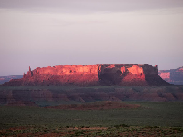
A Mesa on sunset. This is a typical landscape in the land bordered by the Sacred Mountains.
East of Grand Canyon is the homeland of the Navajo, who call themselves Diné, "the People". According to their own traditional origin story, the Creator has told them to live in their land bordered by four Sacred Mountains. Most of this land is today included in Navajo Nation, a self-governed territory of the Navajo. It occupies parts of three U.S. States, Arizona, New Mexico and Utah.

On our travels we prefer small private accommodations over chain hotels. For example the "Grandma accommodations" in the Balkans and small B&B's in Ireland offer great deals in regards to price, quality and, above all, ambience. This time we spent two nights on a farm near Many Farms village. We booked it through Airbnb. The place was rather basic - earth floor and no running water, but functioning WiFi. During our short visit we got at least some insight into modern day life among the Navajo, much more than we would have had we stayed in a roadside motel.

We stayed in a hogan, a traditional Navajo dwelling. The Arizona summer was hot, but even during the day the hogan remained reasonably cool. As the farm was situated in a high elevation on a mesa, it got almost chilly at night. We didn't need the wood-burning stove for heating, though, but I'm sure it's necessary in winter.
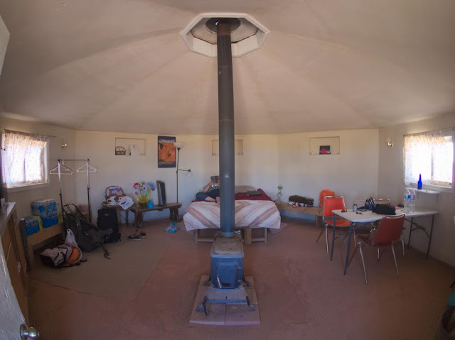
Hogan from the inside...
...and from the outside. This is a "female" hogan: a "male" one has a porch-like extension in front of the entrance. "Female" hogans are for accommodation, "male" hogans for ceremonial purposes. The entrance always faces east and the rising sun.
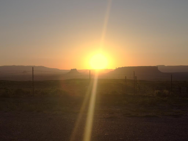
Our hogan was equipped with all necessary things for accommodation, but also with travel guides and books on the Navajo and their land. The surrounding landscape was incredibly beautiful. We took a walk in the evening, to a small canyon situated literally on the back yard, and were accompanied by our host's two friendly dogs. When it got dark, we got to see the stars without any disturbing artificial light. My personal highlight of our four-week trip was a morning coffee sitting in front of the hogan, the dogs and horses keeping me company, while Jóhonaa'éí (the Sun, literally "He who rules the day"), rose from behind  a mesa.
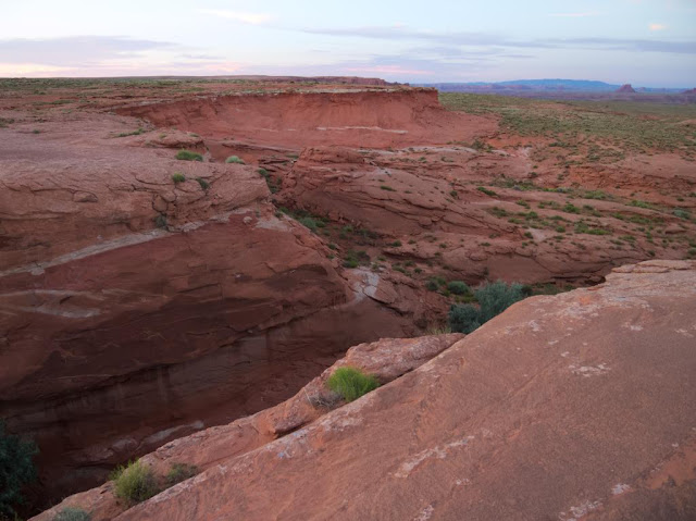
We don't have a canyon like this in our back yard.
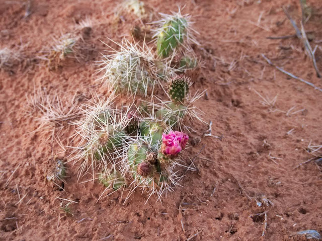
Blossoming cacti neither.
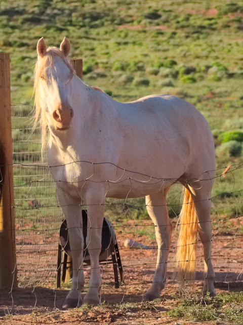
As an urban dweller I am unaccustomed to the company of white horses when I'm having my morning coffee.
"...the indian sun is rising instead of going down..." (Johnny Cash: Navajo)
Navajo Nation is the largest self-governing Native American territory in the United States. According to official statistics the Navajo are the second most populous Native people. They are more than 300 000, majority of whom speak Navajo at home. It seems that the existence of the Navajo as a nation is secure. I think it can be stated that they have been more successful in dealing with settlers from Europe than many other Native American peoples.

However, there are many tragic and horrible chapters in the history of the Navajo. The most sinister probably is "The Long Walk", a forced relocation by the U.S. Military to Bosque Redondo reservation in New Mexico in 1864-1866. The conditions in badly overcrowded reservation and on the way there were unbearable. Thousands died of hunger and disease. The relocation caused also spiritual suffering, since according to their traditional beliefs the Navajo were meant to live in the land the Creator gave them, the land bordered by the four Sacred Mountains, and it would be impossible for them to succeed elsewhere. In 1868 the Navajo leaders managed to negotiate a treaty granting them the right to return home. This is exceptional in the story of the United States, land once taken from Native Americans has not often been returned.
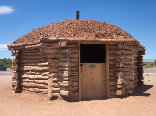
A historical hogan in the Canyon de Chelly visitor center.
There is also another interesting chapter in Navajo history connected to the U.S. Military. During the Second World War young Navajo men were drafted to signal troops an deployed on the Pacific front. Based on their complicated mother tongue, they created a radio signal code which the Japanese were never able to break. The impact of the "Code Talkers" to the outcome of the war was significant, and their effort for the United States is a great source of pride for many Navajos even today. There were Code Talkers from other Native American peoples, too, but the Navajo were by far the biggest and consequently most influential group.
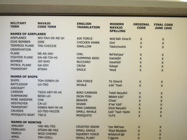
Navajo code explained in the Monument Valley museum.
Today the Code Talkers are remembered as national heroes, but during the war they were treated as second-class citizens. For example, in New Mexico the Native Americans were banned from voting until 1962. Most Navajos of the Code Talkers' generation were educated in Federal Indian Schools. There they were prohibited from speaking languages other than English. As schoolchildren they might have been beaten for speaking their own language. As adults they were awarded medals for it. Oh, the irony of history.

From a traveler's point of view, the Navajo Nation isn't that different from other regions of the Southwest United States. The small towns are no different than others in Arizona, Utah or New Mexico. However, alcohol is prohibited, like in most other Native American-governed areas. Spoken Navajo can be heard sometimes, also on  radio, but English is far more common. Like all Americans, the Navajos we talked to were very polite, helpful and friendly, and wanted to know where we are from. In one respect they were a little different than most other Americans: the Navajo generally speak less loudly. I understand that needlessly rising one's voice is considered impolite.

There's one thing connected to the Navajo self-government that may cause confusion fo the tourist. In the USA, the states can decide many things themselves, for example whether to observe the daylight saving time or not. Arizona doesn't, but the Navajo Nation does. Consequently, the Navajo are an our ahead of the rest of Arizona in the summer, but at the same time as all of Utah and New Mexico. As if that wasn't complicated enough, the Hopi, whose lands are completely surrounded by the Navajo Nation, observe the Arizona time. Make sure you consider this when asking about opening times and such!

The fusion of Navajo traditions and modern popular culture has created some interesting results, such as  Navajo Metal and a Navajo-language version of the original Star Wars movie. Generally speakin, I couldn't care less about any beauty contest, but I do respect Miss Navajo Nation, who has to prove her skills in sheep butchering, among other things. To people interested in contemporary Navajo culture, I recommend Jim Kristofic's book Navajos wear Nikes, which is also available as an e-book from  Amazon. And of course, travel to Navajo lands and see it yourself!

We visited the land bordered by the four Sacred Mountains from June 14th  to 17th 2015.

lauantai 29. elokuuta 2015

The Canyon

Bright Angel Point, the first part of the Canyon we saw. Click this to see the full-sized panorama picture.
In Northern Arizona, the Colorado River has in the course of about 17 million years carved a really, really big hole in the ground. The Grand Canyon is 1857 meter (6093 feet) deep, 29 kilometer (18 miles) wide, 447 kilometer (277 miles) long and makes you feel very, very small.
Point Imperial, the highest point on the Rim.
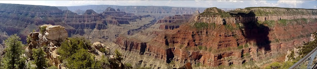
Panorama of Point Imperial. Full-sized picture is here.
Today the Grand Canyon is one of the most popular tourist destinations of the World. It gets approximately 5 million visitors every year, which is funny to us, because that's also roughly the population of Finland. About 4,5 million only visit the southern rim of the canyon. This was one of the reasons we decided to visit the North Rim. It was crowded enough, too, even though we visited in June, before the busiest summer season. (A friend recommended North Rim, for which we're thankful. Thanks again, Ruth.)
A lot of wildlife can be seen in and near the Canyon, there are even bisons. We only saw deer and lizards.
The scenery in Grand Canyon is unbelievable. I found myself wondering if it actually is real, or a great hoax made with powerful computer graphics and advanced 3D projection technology?
Angel's Window vantage point. I think the name refers to the hole in the rock, visible on the right.
A baffling thing about the Grand Canyon is that in many places it would be easy to walk some 20 meter (60 feet) from the Rim without knowing that the Canyon is there. As we were driving on the scenic roads, there often was a forest on one side of the road, not unlike the forests in Finland, and a vertical half-mile drop on the other.
The view from Angel's Window pictured with a fisheye lens.
We spent one full day on the Canyon. That was enough to visit several vantage points in a relaxed pace. We also had time for a lunch in Grand Canyon Lodge. Food was good and not as horribly overpriced as I would have expected.

Walhalla vantage point.
Perhaps the most impressive thing we saw was the Grand Canyon sunset, observed from the balcony of the Lodge. We were smart enough to capture first-row seats early. The light and colors changed constantly as the sun descended. The view left us (but not the American tourists) speechless. The sunrise would probably be equally impressive, but since in June it takes place before 6 am we missed it.

The last rays of the setting sun.
In January, almost six months before our trip, I tried to book us a room on the North Rim within the National Park. Everything was fully booked. We ended up staying in Jacob Lake resort. Confusingly, there's no lake anywhere near it. The drive to the Canyon Rim took about one hour each way. When we returned, in the dark after sunset, things got a little scary. There were a lot of deer crossing the road, and even a cow and a calf. There was even a warning sign for bisons, but thankfully we saw none on the road.

A white-tailed Kaibab Squirrel in Jacob Lake. This kind of squirrel only lives near the North Rim of Grand Canyon. Squirrels on the south are different subspecies: the Canyon is an unbridgeable obstacle for squirrels.
We found Jacob Lake a nice place to stay. Prices were a little high, but so they are everywhere near attractions like Grand Canyon. Our cabin was comfortable, and the resort has a shop, a restaurant and a bakery. Chocolate and raspberry cookies get our highest recommendation. As experiences go they rival the Grand Canyon sunset. The cookies alone make Jacob Lake worth a stop! Sunset Amber Ale brewed by a local brewery was tasty.

The breakfast was not included in accommodation prices but featured lovely American-style pancakes with sponge like texture, so that they can absorb ridiculous amounts of delicious maple syrup. Those fortunate enough to have experienced an American breakfast know what I mean. Jacob Lake also offers lectures on things like landscape photography and history of the Navajo around Grand Canyon. Unfortunately we didn't have time to attend any.

We visited Grand Canyon on June 13th 2015.

tiistai 4. elokuuta 2015

Pleasant surprises in Utah

Zion National Park.
At least in Finland the name of Utah conjures images of fundamental mormons, restrictive legislation and generally conservative social climate. For us Utah was one of the most pleasant surprises of our trip. Of course we cannot claim to know the state very well at all. We only popped in twice from Arizona to the southernmost part of Utah and spent only about 24 hours in the state, including one overnight stop.

A small Scutellosaurus in St. George.
Our first stop in Utah was the St. George Dinosaur Discovery site. I have wanted to have my own pet dinosaur been very interested in dinosaurs since an early age. Actually I'm kind of fanatic about them. As there are no dinosaur fossils where I come from (thanks a lot, Ice Age), I was very keen to see an authentic fossil site. Some exceptional footprint fossils, about 200 million years old, were discovered in 2000 at Johnson Farm, close to central St. George.

Now there is a small but well-kept museum displaying footprints and other fossils, and real dinosaurs but unfortunately one is not allowed to pet and feed them life-like reconstructions of jurassic dinosaurs.

I know that some people lead empty and meaningless lives are not as enthusiastic about dinosaurs as I am. Maybe not everyone would be as interested in the St. George museum as me. However, I highly recommend the place for those who care about dinosaurs even a little. It is not a huge museum, so it makes a good stop in a long day of driving: if your schedule is busy, four hours half an hour is enough to get a meaningful overview of the exhibitions.
Dinosaur fottprints from 200 million years ago.
From St. George we continued towards the Grand Canyon, but decided to make a detour through Zion National Park. We drove through it on a scenic mountain road constructed in 1930. The scenery was awe-inspiring, and very different from what we had seen in Yosemite, for example. Through millennia water has eroded red sandstone, which is soft and crumbles easily. This has resulted in some peculiar, dream-like shapes.

Checkerboard Mesa in Zion.
Up on the mountains the temperature dropped to a tolerable level, well under 30 centigrade (86 Fahrenheit). Of course, there's much more to see and do in Zion than we had time for.
Up in the mountains of Zion.
Soon after leaving the National Park we stopped by a beautiful small pond for a snack and to switch drivers. At the same time, a group of six bikers pulled to the same parking lot. They looked exactly the kind of bikers one sees in American movies, long hair and beards, black leather vests, and they definetely did not wear helmets when riding - a bit of a scary-looking bunch. I admit that I was prejudiced and a little concerned when  they approached us. There was absolutely no reason to be afraid - they asked us, very politely, if we could kindly take a picture of their group in front of the pond!

A couple of days later, after visiting the Grand Canyon, we made an overnight stop in the small town of Bluff, Utah, close to the Arizona border. I have been to the USA once before, then in New York and Boston. Then I heard many Americans describe New Yorkers as a unfriendly and rude. I was surprised, as I found them very nice and helpful.

On this trip I understand where this comes from. All the people - really, every one - we met in rural Utah, Arizona, New Mexico and California were incredibly friendly, polite and helpful. We, reserved Finns as we are, sometimes even felt awkward. I see that in comparison, even a friendly and easy-going city like New York may indeed seem unwelcoming.

An example of this helpfulness: we needed to do laundry in Bluff. We arrived in the town late in the evening, and the only laundry shop was just closing. Before I could say anything, the manager told me she lived right across the street, so I could take my time washing our clothes and knock on her door when I'm done so she can close the shop after that, no problem, hope you've enjoyed your trip so far, oh you've seen the Grand Canyon, magnificent isn't it, make sure not to miss Monument Valley...

"Polygamy Porter, proudly brewed in Utah". A Utah brewery pokes fun at fundamental latter-day saints. Quite tasty, too.
If you ever visit the region, Bluff gets my warm recommendations even though there's not much to see and do in the tiny town itself. Landscape is beautiful and there are many interesting places nearby. We stayed in  Kokopelli Inn and liked it. There are a couple of other motels and inns, too.

We visited the dinosaurs of St. George and Zion National Park on June 12th 2015. We stayed in Bluff June 14th to 15th.