Näytetään tekstit, joissa on tunniste National Park. Näytä kaikki tekstit

maanantai 10. syyskuuta 2018

Tatra, or Couch Potatoes in the Mountains

Mountain landscapes of Štrbské pleso.
I probably have stated this before: we are no sportspeople. We will walk considerable distances in cities or maintained paths, but leave more demanding activities like, say, mountain biking, to others. The High Tatras - Vysoké Tatry in Slovakian - is a very suitable mountain destination for people like us. Of course, there's plenty to do there for hikers and mountaineers, too, but I am not the one to write about that.

The High Tatras are the highest part of the Carpathian mountains, and are divided by the border between Slovakia and Poland: the highest peaks of both countries are there. Most importantly the High Tatras are incredibly beautiful, whether viewed through a train window from the valley below or from the top of one of the mountains. See:

Tatra seen from the city of Poprad.
Lomnický štít (2634m, left) and Kežmarský štít (2588m, right) seen from Skalnaté pleso.
What makes the High Tatras particularly suitable for couch potatoes is the TEŽ, Tatra Electric Railroad. It has taken travelers up to the mountains from the city of Poprad for more than a century. A day ticket, allowing one to travel as much as one manages within a day, was 4€ in July 2018.

A TEŽ train in Tatranská Lomnica.
We stayed in Poprad, and took the train to the village of Štrbské pleso. The original plan was to get off at Popradské pleso and walk to Štrbské pleso from there - there apparently is a non-demanding hiking path connecting them. However, we changed our plans because the weather forecast promised rain and we knew that in Štrbské pleso we would not be too far from shelter. There was no rain. On the edge of village, there is a picture-postcard-beautiful mountain lake, around which there is a well-maintained, easy path.
The lake is surrounded by mountains.
Štrbské pleso - few vowels, plenty of views.
Hotel Panorama, the weirdest piece of socialist architecture in Štrbské pleso village.
The high point of our visit to Tatra  was a cable car ride to the top of Lomnický štít, 2634 meter above sea level (pun entirely intended). It involves no less than three cable cars. First is a small and scary one from Tatranská Lomnica to an intermediate station, where you change to a fancy and modern one, which in turn takes you to the Skalnaté pleso mountain lake. From there you continue in a tiny, completely terrifying cable car to the top. Even if you are, like us, afraid of heights, I warmly recommend it because of the incredibly amazing views. Being a sea-level dweller, I felt quite dizzy, not sure if it was because of vertigo or altitude sickness.

Up on the top we were almost swallowed in a cloud.
The light up high is different, or at least feels so.
We were advised to book the cable car tickets as early as possible. Since I didn't get the online booking system to work, we went quite early on a Sunday to inquire about tickets. The next available ones were for Monday afternoon. This was in late July, just as the busiest summer season in Central Europe was beginning. Weekends may be more busy. If you can't get tickets all the way up to Lomnický štít, or if you're unwilling to pay the undeniably steep price of 49€ per person for return ticket, consider taking tha cable car to Skalnaté pleso only. Advance bookings are not necessary there, and Skalnaté pleso with has beautiful views, reasonably-priced restaurant and some easy hiking paths. It's worth braking your journey there anyway, either going up, coming down, or both.

With the exception of  Lomnický štít cable car, the general price level in Tatras is pleasantly low compared to most of Europe: 10€ buys a good meal, with drinks, in most restaurants, the very tasty Slovakian beer is usually less that 2€ a pint, and even accommodation is affordable. We paid less than 30€/night for a room for 2, with bathroom, in Poprad.

We visited the High Tatras in July 27th to 31st 2018.

lauantai 21. lokakuuta 2017

Driving in Clouds


If you're headed from, say, Atlanta or New Orleans towards Washington DC or New York (or vice versa) you can, instead of boring Interstate Highways, drive almost a thousand miles of beautiful and slow mountain roads. The Great Smoky Mountains National Park is in the Southern end of the route, the  Shenandoah National Park in the North. They are connected by a scenic mountain route known as the  Blue Ridge Parkway.

When within the clouds, you don't really see the scenery, but it may still be beautiful.
We drove about half of those mountain miles in early June 2017. As you can see from the video above, the weather was not really favorable, except towards the end of the journey. We had also planned a tight-ish schedule. We occasionally headed down from the mountains to the Interstates in the valleys, where it's possible to travel a lot faster. It was also a matter of safety: the winding mountain roads are a little scary if the visibility is poor, especially considering the abundant wildlife. We saw deer, wild turkeys, opossums (we suppose), and one rattlesnake. When darkness falls, it is better to drive on an illuminated highway than in the dark mountain roads - an even better idea is to reach your destination before sunset.

Deer in the Great Smoky Mountains National Park.
As usual in the USA, things have been made easy for a car tourist. There are vantage points every few miles, and a lot of differnet sights to see, so many that even the most duty-conscious tourist can't possibly visit them all (and some of the sights are, how should I put this, questionable). We recommend Museum of the Cherokee Indian in Cherokee, North Carolina, just south of Great Smoky Mountains, and the Mabry Mill, a cute open-air museum in southern Virginia, as well as Monticello, home of Thomas Jefferson, the third president of the United States and the author of the Declaration of Independence (I'm planning on writing more about Monticello later). There are hiking trails and other opportunities to experience the Great Outdoors, but we drove past them, because of the schedule and couch potatoness.

Like many Native American peoples, the Cherokee smoked tobacco in this kind of stone pipes, often in their ceremonies.
The Cherokee played a ball game they called the "Little Brother of War" with sticks like this. The exhibition in the Cherokee Museum is quite impressive, including a presentation of the "Trail of Tears" (or, literally, "The Road on which They Wept"), the forced transfer from the traditional Cherokee lands to Oklahoma, where most of the Cherokee still reside.
The green Mabry Mill is fairytale-like, at least in June.
We do not recommend Pigeon Forge, Tennessee at the southern end of the route, not to travelers like us anyway. There are most bizarre Las Vegas-like plastic tourist traps, such as the half-scale half a Titanic, including the Iceberg. Traveling on mountain roads may be slowed down by not only weather but also traffic jams, especially during the holiday season and on weekends. The route is quite popular and tens of millions of people live nearby.
Titanic. Well, half a Titanic. And the Iceberg.


Huge motor homes, towing "rescue boats", are frequently seen on U.S roads. Many are much larger than this one seen at a Blue Ridge Parkway picnic area.
Like most US National Parks, Shenandoah charges an admission fee, but there are no road tolls or charges on the Blue Ridge Parkway and The Great Smoky Mountains National Park is free of charge. Practically, the only way to experience the route is a car (or, of course, a motorcycle or such), your own or rented. At least in the summer season, it is possible to reach some places in the The Great Smoky Mountains National Park by public transport.

We drove on the Blue Mountains from June 4th to 6th 2017.

torstai 1. syyskuuta 2016

Maritime History of San Francisco

Balclutha, a full-rigged ship built in Scotland, 1887.
Once upon a time San Francisco wass the most important port on the United States West Coast. No surprise then that there are several interesting museum ships there. If you're as interested in them as I am, you can easily spend a whole week day exploring them.

The San Francisco Maritime National Historical Park, another gem ran by the National Park Service, is situated on the touristy Fisherman's Wharf. It includes several museum vessels, many of which are accessible to visitors. Full-rigger Balclutha sailed in commercial freight traffic from 1887 to 1930, and has an interesting and eventful history. For example, she was the last ship ever to fly the flag of the independent kingdom of Hawaii. There's a well-designed exhibition in the cargo hold about different cargoes transported by the Balclutha. All of the ship is accessible, but climbing the rigging is prohibited. In the captains's salon, in the galley and in the forecastle the visitors can imagine what it felt like to sail an ocean-going sailing vessel, when trips lasted several months.
Captain's salon.
Crew quarters in the forecastle. I don't think the anchor windlass in the middle of the room did much for comfort. The picture is taken with a fish-eye lens and is therefore distorted.
Balclutha's figurehead.
The paddle-wheel ferry Eureka is also very interesting, in a completely different way than Balclutha. She was built only three years later, in 1890, and she's almost as big as the ocean-going fullrigger. She originally transported trainso over the Golden Gate from San Francisco to Sausalito. After the First World War she was converted to a passenger and car ferry. After the Golden Gate Bridge and Bay Bridge were completed in th 1930s, most of the numerous ferries of the San Francisco Bay were decommissioned. Eureka, however, remained in traffic until 1957.
Entrance to the Eureka.
The car deck.
The passenger deck. It only took about half an hour to get from Sausalito to San Francisco, but there was a restaurant serving full meals on the Eureka.
Technologically Eureka was quite old-fashioned already when built. Paddle-wheels had largely been replaced by propellers, and the one-cylinder steam engine was based on 18th-century technology. The machinery was simple, and reliable on a vessel designed for continuous short trips. It was important to keep maintenance costs low and time required for repairs short.
Eureka's engine, picture taken with a fish-eye lens..
The engine explained.
The Historical Park's collections include other vessels as well, like thid paddle-wheel tug.
The museum, also included in the Historical Park, was under renovation, but we could see some nice scale models in the lobby. This one depicts San Francisco harbor around the 1849 gold rush. The sailing vessel Niantic had arrived from the U.S. East Coast, sailing around Cape Horn. The owners decided to convert it to a shop and tavern - at the time, the potential profit was greater than in shipping industry.
Another model featured the crew in masts.
A few blocks away there's a Liberty-class freight steamer Jeremiah O'Brien, built during the Second World War. She's not a part of the Historical Park but ran by an association. She is seaworthy and in navigable condition, and does sail every now and then. In her hold visitors can see an exhibition on the Liberty ships, which were built for war material transports. Between 1941 and 1945, 2710 were built.
Liberty-class freighter Jeremiah O'Brien.
The telegrapher's cabin.
Fist mate's cabin. The radio equipment is not original but for the modern use of the ship.
The Jeremiah O'Brienin operational main engine.
The rescue ladder of the engine room. Would you want to climb this to escape a burning engine room after the ship has been hit by a torpedo?
There's another WWII vessel next to the Jeremiah O'Brien, the submarine USS Pampanito.
Fisherman's Wharf is probably the most touristy area of San Francisco and it is not my favorite place in the city. The museum ships are great, but in addition to them there are mostly plastic, overpriced theme restaurants and souvenir shops. However, there is one more reason to visit the Fisherman's Wharf: The sea lion colony on Pier 39. Jolly creatures. Smelly, though.

Every now and then one should show off for the tourists...
...but mostly it's best just to relax.
We visited the ships on June 5th and 28th 2015.

tiistai 19. huhtikuuta 2016

Muir Woods - very, very big trees

In the shadow of Redwoods.
Here I was born, and there I died. It was only a moment to you. You took no notice." - Alfred Hitchcock's Vertigo, 1958.

There is a lot of forest in Finland. Consequently, it may seem surprising that Finnish tourists travel all the way to California and go to see some trees. However, everything is bigger in America, including trees. The highest tree species of the world, California Redwood, and the biggest by volume, Giant Sequoia, grow in California. These are the biggest living creatures of the world, and among the oldest. Oldest living Giant Sequoia is about 3200 years old.
The very tallest trees are elsewhere, but you can see some really big ones in Muir Woods, too.
Yeah, they're tall.
The closest place to San Francisco to see these giant trees is Muir Woods National monument, one of the sites ran by the excellent National Park Service. Even for people who enjoy other things more than the Great Outdoors, Muir Woods is easily accessible: there are good signposted walk routes and information boards.
"When I grow up, I'll become a 100-meter Giant Sequoia".
The only drawback is common to many other U.S. National Parks: the place is a bit too popular. The footpaths get crowded, and the tourist hordes are sometimes unnecessarily loud. In Muir woods there were even signposts asking the visitors to be quiet in order not to disturb wildlife, but unfortunately many - I would say most - visitors ignored them. We visited on a Monday, but the site was very crowded, parking lots full and a lot of cars were parked dangerously by the narrow mountain road. We would advise against visiting on a weekend, if at all practical. Muir Woods is not the only place to see giant trees in California and the U.S. West Coast. Another popular spot is Wavona in Yosemite National Park. Muir woods is, however, one of the few Redwood and Sequoia forests practically accessible by public transport.
The overall ambience in the forest is tranquil, in spite of all the visitors.
Getting to places on public transport is sometimes laborious in the USA. Trip from San Francisco to Muir Woods is not particularly difficult, but it is slow, it may take more than two hours from city center and one should be prepared to wait when changing buses. From central San Francisco, first take a bus over Golden Gate Bridge to Sausalito or Marin City (for example bus number 70), or a ferry to Sausalito. Then take minubus 66 or 66F (only from April to October, timetables here) to Muir Woods. At least one can pay by Clipper Card in all buses and ferries.
If you're lucky you may see a traditional hippie VW bus when waiting for the bus.
Sausalito is a nice place to stop for a meal or ice-cream, there are a lot of options. Prices are on the expensive side but small town ambience is peaceful and relaxed. The sporty ones - not us! - may want to rent a bicycle from San Francisco: the ride to Muir Woods is demanding, long and hilly, but the views are great.

We visited big trees on June 30th 2015

perjantai 8. huhtikuuta 2016

Our recipe for a Road Trip

Note: this post is written from the point of view of middle-aged Northern European tourists. Americans and others may find most things discussed here obvious and/or boring.
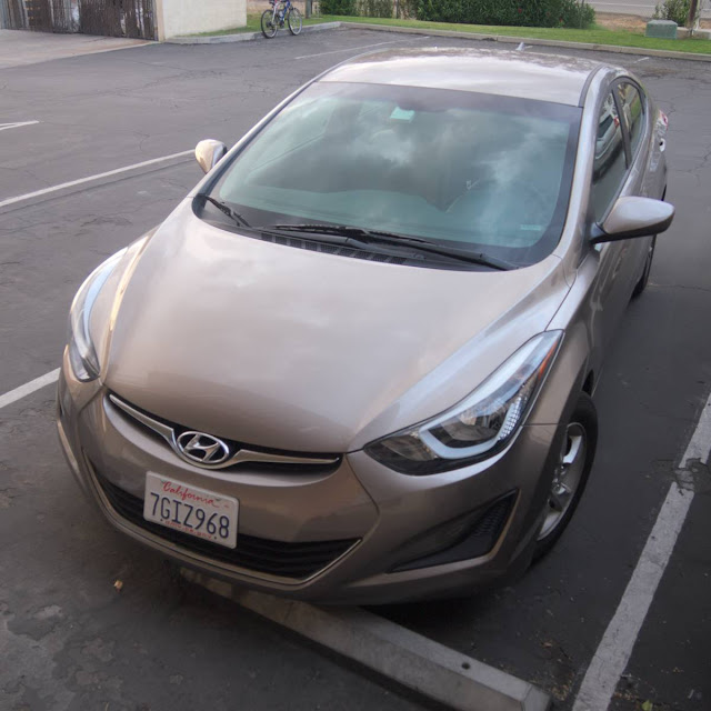
Our faithful ride, a marvel of Korean engineering, Hyundai Elantra.
Four thousand nine hundred and ninety-six kilometer (three thousand one hundred and four miles). Seven National Parks. Five states. Three canyons. Two weeks. One ocean. Traveling the United States by car can be an unforgettable experience, and many interesting places are impossible or very difficult to reach without a car.

I've been asked some questions about how we arranged our road trip, and I had quite few things to sort out and think about - I was even worried about a few things. Everything went very well after all. So, below a brief account about how we arranged the practicalities of our road trip. Obviously, I do not claim that all our decisions were best possible (or even good), but our recipe produced a very enjoyable road trip.

This post is about a road trip we made in the USA, in the states of California, Nevada, Arizona, Utah and New Mexico in June 2015. One should note that laws and regulations may vary widely between different U.S. states, as may prices of fuel and other things. Of course, the exchange rate between the dollar and euro, or your local currency, will probably fluctuate which has an effect on your projected travel costs. At the time of our trip one euro was worth about 1,1 dollars. About a year earlier the rate was 1,3 - a remarkable difference.

The Car
Rental cars in the USA a very affordable compared to, for example, Finland. We managed to secure our travel dates well in advance, which was fortunate because booking the car months before the actual rental saved a considerable amount of money. We ended up booking our car from Budget, because it was cheapest option available in places that were practical for us. The price of our 2-week rental including unlimited miles was 300,82€. We had also considered renting a campervan from a company like Escape or Jucy, but we came to the conclusion that renting a normal car and staying in cheap motels would probably not work out more expensive and is probable more pleasant for us. That said, the campervans might be great for people with different priorities than us. We actually saw quite a few of them in places like Yosemite and Grand Canyon.

Pros of renting from Budget included that we could return the car in a different location that we rented from without any extra fee, as long as both the rental and return locations were in California. I understand many other companies, but not all, have the same policy. We picked the car up in the small airport of Merced, CA, which we reached conveniently by bus from Yosemite National park. We returned it in San Francisco international airport, as we stayed for a week in San Francisco Bay area after the road trip. Since we were coming to the city from the south, the airport was easier to reach than midtown locations.

Most companies charge a surcharge for under 25-year old drivers and may not allow under 21-year old drivers at all. As we are old, we avoided such troubles. According to a Californian law, the spouse of the signatory of the rental agreement is allowed to drive, provided that he or she has a driving license, and the rental company has no right to collect a surcharge for him or her. This was an advantage to us, and we were not asked to provide any marriage certificate. The surcharges for second (and third, fourth and so on) drivers may be significant.

Of course, different companies offer very different deals, but usually free mileage is included and there seldom are limitations for visiting different U.S. states. Our Budget deal would have allowed us to drive to and in Canada, but Mexico was strictly off-limits. Obviously, one should read the terms and conditions of the rental agreement carefully.
On the Californian desert: good, straight road, easy and comfortable to drive.
The process of picking the car in Merced was straightforward, but took a little bit longer than necessary because the clerk, who, like most Americans, was very friendly and polite, had some problems with Budget's computer systems. This was not a big deal at all. Returning the car in San Francisco was a quick and efficient process. Sometimes an international driving license is recommended for the USA, but our EU-standard licences issued in Finland were adequate for Budget. No police officers or other authorities asked to see our licenses. When picking the car up, a deposit was charged on my credit car, I think it was the same amount as the full price of the rental (i.e. 300,82€). It took some two days after returning the car before the money was returned.

The car we got was a Hyundai Elantra, called "compact" in the U.S. but would be considered a normal-sized small family car in Europe. The transmission was automatic, as it practically always in in the USA. The rental clerk offered us a bigger car (Nissan Murano) for the same price, but we declined since the Elantra was easily big enough for the two of us and probably more fuel-efficient. I've heard that the rental companies often do this. However, we were not offered useless extra insurances, even though I had been warned that it is a common practice. Our rental included compulsory insurances and roadside assistance, and the extra insurances often covers things that are already covered by your travel insurance - never ever set foot in the United States without a travel insurance that covers emergency medical treatment.

I can't come up with any complaints about the car. It was easy to drive, on a highway it ran more than 40 miles per gallon (obviously less on the mountain roads), the seats were comfortable, the sound system more than adequate and air-conditioning powerful, which is very, very important in June driving around Southwest USA.

The Driving
Our route was, mentioning the places where we picked the car up and returned it, and the places we stayed overnight, Merced, CA - Bakersfield, CA - Las Vegas, NV - Jacob Lake, AZ (2 nights) - Bluff, UT - Many Farms, AZ (2 nights) - Grants, NM - Zuni, NM - Needles, CA - Maricopa, CA - Paso Robles, CA (2 nights) - Santa Cruz, CA - San Francisco, CA. There was lots and lots to see along the route, see our other posts about the road trip.

We do not consider ourselves exceptionally talented drivers, and at home we do not have a car at all. Consequently we were a bit worried about driving beforehand. This was completely unnecessary. Driving in the USA is generally easy, very easy. Most of the roads are multiple carriageways, like Finnish motorways. Signage was excellent, better than in Finland, and most roads we drove on were in very good condition, except some more remote roads in Arizona and New Mexico - and even they were not that bad.
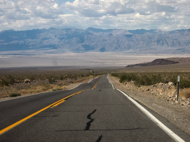
A long straight and no other traffic to be seen, but thankfully the views are beautiful and dramatic. Here we are approaching the floor of the Death Valley.
Traffic was low on most roads we traveled. We met congestion only three times: in the beginning of our trip in Central California, in the city of Las Vegas and on our final driving day from Santa Cruz to San Francisco. In heavy traffic and on highways the American drivers seem to be more civilized than the Finnish ones, they even give way in interfaces if necessary - generally speaking: obviously there are a few dimwits everywhere (my warmest regards to the driver of a blue Chevrolet Suburban in Las Vegas, have you ever heard about turn signals or wondered why they are called turn signals?). The general respect for traffic regulations seemed to be on a higher level than in Finland, the complete disregard for speed limits on Californian highways being an exemption.

We only encountered two problematic situations while driving. Returning from Grand Canyon to our cabin in Jacob Lake, self-destructive deer were constantly jumping on the dark road. Our accommodation in Navajo lands, near Chinle, AZ, was very remote and the last stretch of the road was in a very bad condition after heavy rain. We were seriously worried about our little Hyundai's ability to take us to our destination. The 4WD pickups that the locals drive had few problems, though.

For navigation we used my rather basic Android smartphone and free HERE Maps -application. That worked. However, the aforementioned last stretch of road to our accommodation on Navajo Lands was unknown to the application - according to our host, this is the case with all navigation software. Sometimes it took a while before the phone managed to establish a GPS connection, but this was not a big problem.
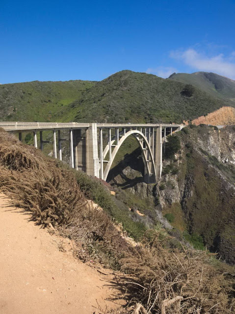
We highly recommend driving California Route 1 along the Pacific coast. Bixby Bridge pictured here.
Compared to Finland, fuel is very cheap in the U.S., even in the higher end of the very wide price range. The prices differ wildly from state to state and also within states. I didn't collect all our fuel receipts, but the cheapest we paid was $2.69 for a gallon (1 gallon = 3,79 liter) in Zuni Pueblo, New Mexico, whereas the most expensive was $4.59 in San Francisco. I would say that the total fuel costs on our almost 5000 kilometer (3100 mile) trip were no more than 300€ - try that in Europe! Of course, many factors affect your fuel costs - the roads you drive on, the weather, your driving habits and obviously the car you drive. A big SUV could easily burn twice as much fuel as our compact car.

The Accommodation
We mostly stayed on roadside motels, the like of which you have seen on American TV and movies. They provided comfortable accommodation with very few complaints. Most common problem were very noisy air conditioning devices (solution: earplugs). In addition to motels, we stayed in a cabin near Grand Canyon, in a traditional Navajo hogan in rural Arizona and in a historical inn in Zuni Pueblo, New Mexico. These were all pleasant and recommendable experiences and more pleasant than the motels, even if there was nothing wrong with the motels either.
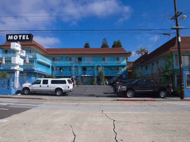
Aqua Breeze Inn, Santa Cruz, California.
An interesting thing about motels is that there seemed to be little, if any, correlation between price and quality. The law of supply and demand seems to work. The most expensive night, almost 100€ for two, was in Santa Cruz, California (a lot of demand, limited supply). The lowest prices we paid, all slightly less than 40€ for two, were in Las Vegas, Nevada (enormous demand, endless supply), in Bakersfield, California and in Needles, California (limited demand, a lot of supply). Most Europeans will find the American habit to advertise accommodation prices (and many other prices) without taxes strange. It is a common practice in the USA and does not imply dishonesty. This means that if the price of a room is listed at $50 you will actually pay some $55-65. The taxes, too, vary from state to state and locality to locality.

Many but not all motel prices included a breakfast of usually questionable quality. All rooms we stayed in were equipped with a coffee maker and/or water cooker and free coffee and tea. Usually there was a refrigerator and a microwave oven, too.

The average nightly accommodation price over 14 nights was about 67€ for two including taxes. Those traveling in groups of more than two can probably get slightly lower prices per person, most motels seemed to have rooms for four or even larger groups. Obviously, the seasonal variation in prices may be considerable, especially in popular holiday destinations like Grand Canyon. Of the motels we stayed in, the one in Bakersfield probably offered best price/quality ratio, as the rooms were newly renovated and the breakfast was adequate. The place in Santa Cruz was considerably more expensive than others of similar quality. There, too, we had no complaints about quality or service, everything worked, even though the furniture, refrigerator and air conditioning dated from the days of Ronald Reagan's presidency.

We booked all our accommodations well beforehand, before we even left Finland. In case of popular destinations, such as Grand Canyon, this is highly recommended. Of course, having everything pre-booked seriously limits flexibility: on the other hand, it provides a certain level of safety. Bookings made on booking.com usually include free cancellation in case of change of plans: however, this is not always the case. In this age of smartphones and tablet computers it would probably be easy to make bookings on the road a day or two in advance, and I'm confident the traditional way, walking to a motel reception and asking for a room, works as well.

The nutrition for body and spirit
One needs to eat on a road trip, too. Finding somewhere to eat shouldn't be a problem, there are numerous roadside eateries with long opening hours almost everywhere. Unfortunately the most common fast food chains do not provide the best quality, or even price/quality ratio. The prices are only a little lower than those in Finland. Living two weeks on, say, Taco Bell and Denny's food will probably result in a considerable weight gain. Of course, self-catering is an option, too: also supermarket price levels are close to Finnish levels, particularly California seems actually more expensive than Finland.

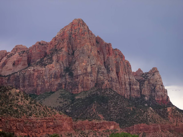
Zion was one of the national parks we visited.
We highly recommend purchasing an annual National Park pass for $80. It provides access to all National Parks, National monuments and other sites administered by the NPS for a year starting the day of purchase. Usually a car and up to three people accompanying the pass owner are admitted, too: this was the case in every national park we visited. Because the greatest places in the USA are mostly National Parks, it definitely is worth buying. If you visit three parks or more, you probably end up saving money.

So, how expensive is it exactly?
We paid:
  • for car rental about 301€
  • for fuel about 300€
  • for accommodation for 14 nights about 938€, if you can travel off-season you can potentially save a lot of money here
  • for national parks about 72€
In other words, slightly more than 1600€ for two people in two weeks, or about 115€ a day.

In addition, of course, there are other costs that everyone has to budget for according to their needs and preferences:
  • Prices of flights vary greatly, if you can travel off-season you may save lots and lots of money.
  • For food you should budget at least as much as for food in Western Europe.
  • Entrance fees to places other than National Parks. They are sometimes steep. For example, we paid, not including tips for the guide (unless you have real complaints, do tip the guide, this is, after all, the USA), $48 a person for a guided tour of Antelope Canyon and $23 a person for tour of Acoma "Sky City", not cheap but worth it. 
  • As much money as you want to spend on souvenirs, shopping, gambling in Las Vegas or Native Casinos, drinking beer and wine, and whatever you want to spend your money on: the United States in general provides ample opportunities to spend money.
We made our Roadtrip on June 10th to 24th 2015

lauantai 26. syyskuuta 2015

The valley of Rocks

When approaching Monument Valley from Northeast on route 163, it seems to be mandatory to take a picture like this.
On the Arizona - Utah border, there is a place called Tse'Bii'Ndzisgaii, "The Valley of Rocks", one of the great natural wonders of Southwestern USA. The white man calls it Monument Valley. It is one of the most photographed places in the World, and has appeared in numerous movies, cartoons and games. That's no surprise, the sandstone formations look like Salvador Dali's feverish hallucinations, but they do exist, however difficult it is to believe in them.

Places like Monument Valley make a visitor - at least me - feel very, very small. The formation of the strange natural sandstone sculptures have taken millions of years, and not even stone is forever. What meaning can my temporal existence have compared to that?

"The mittens", left and right.
Monument Valley is administered by the Navajo Nation. From a visitor's point of view there is no significant difference to federally run national parks of the USA. There's an entrance fee and a visitor center and a small but nice museum with exhibitions on Monument Valley and Navajo history. The restaurant at the visitor center is less overpriced than I would have expected. There's also a shop where one can buy, among other things, art by Navajo artists, with a proof of authenticity. There's even a hotel within the Monument Valley area, but that was a bit too pricey for us, even though a sunrise and sunset seen from the balconies would, no doubt, been quite an experience.

We do not buy many souvenirs, but from Monument Valley we purchased this sand painting made by Navajo artist Anna Chee. In YouTube, there's a 1949 film about the making of a traditional sand painting (it's silent and the sand painting begins at 18:50, before that there are other interesting things like Monument Valley landscapes)
In Navajo lands, there is a lot of very fine red sand. When it rains, the sand either turns to mud or flows away with the water. When we visited Monument Valley, it was baking under a merciless sun, but it had rained on the previous days. Conequently, the 17 mile gravel road in the valley had either turned to mud or flown away with the water, and we decided not to drive it. We did, however, visit the John Ford point, a vantage point named after the movie director known for his westerns.
Monument Valley has "played" the role of a foreign planet in many movies. No surprise.
In August 2015, as I wrote this, there was a miserable natural disaster going on near Monument Valley. More than 11 million liter (3 million US gallons) of waste water contaminated with heavy metals was accidentally released to San Juan river, to the north of Monument Valley. Many Navajo farmers rely for the river for irrigation water, and their crops are in danger when the water is unusable. Most of them are not particularly wealthy people to begin with, and their entire livelihood is endangered by the waste water spill.

We visited Monument Valley on June 15th 2015.