 |
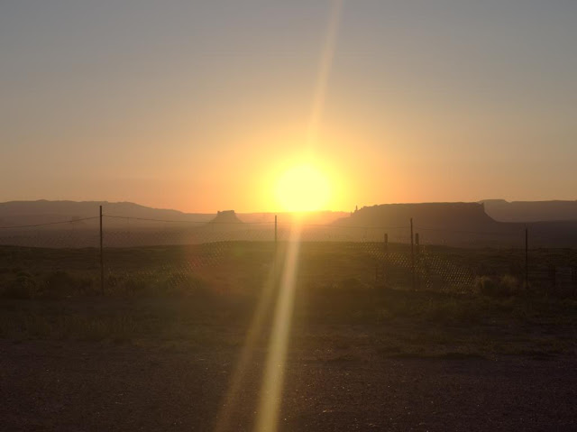
| A Mesa on sunset. This is a typical landscape in the land bordered by the Sacred Mountains. |
East of Grand Canyon is the homeland of the Navajo, who call themselves Diné, "the People". According to their own traditional origin story, the Creator has told them to live in their land bordered by four Sacred Mountains. Most of this land is today included in Navajo Nation, a self-governed territory of the Navajo. It occupies parts of three U.S. States, Arizona, New Mexico and Utah.
On our travels we prefer small private accommodations over chain hotels. For example the "Grandma accommodations" in the Balkans and small B&B's in Ireland offer great deals in regards to price, quality and, above all, ambience. This time we spent two nights on a
farm near Many Farms village. We booked it through
Airbnb. The place was rather basic - earth floor and no running water, but functioning WiFi. During our short visit we got at least some insight into modern day life among the Navajo, much more than we would have had we stayed in a roadside motel.
We stayed in a
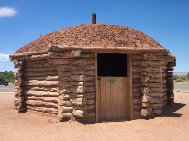
hogan, a traditional Navajo dwelling. The Arizona summer was hot, but even during the day the hogan remained reasonably cool. As the farm was situated in a high elevation on a mesa, it got almost chilly at night. We didn't need the wood-burning stove for heating, though, but I'm sure it's necessary in winter.
 |
| Hogan from the inside... |
 |
| ...and from the outside. This is a "female" hogan: a "male" one has a porch-like extension in front of the entrance. "Female" hogans are for accommodation, "male" hogans for ceremonial purposes. The entrance always faces east and the rising sun. |
Our hogan was equipped with all necessary things for accommodation, but also with travel guides and books on the Navajo and their land. The surrounding landscape was incredibly beautiful. We took a walk in the evening, to a small canyon situated literally on the back yard, and were accompanied by our host's two friendly dogs. When it got dark, we got to see the stars without any disturbing artificial light. My personal highlight of our four-week trip was a morning coffee sitting in front of the hogan, the dogs and horses keeping me company, while
Jóhonaa'éí (the Sun, literally "He who rules the day"), rose from behind a mesa.
 |
| We don't have a canyon like this in our back yard. |
 |
| Blossoming cacti neither. |
 |
| As an urban dweller I am unaccustomed to the company of white horses when I'm having my morning coffee. |
 |
| "...the indian sun is rising instead of going down..." (Johnny Cash: Navajo) |
Navajo Nation is the largest self-governing Native American territory in the United States. According to official statistics the Navajo are the second most populous Native people. They are more than 300 000, majority of whom speak Navajo at home. It seems that the existence of the Navajo as a nation is secure. I think it can be stated that they have been more successful in dealing with settlers from Europe than many other Native American peoples.
However, there are many tragic and horrible chapters in the history of the Navajo. The most sinister probably is "The Long Walk", a forced relocation by the U.S. Military to Bosque Redondo reservation in New Mexico in 1864-1866. The conditions in badly overcrowded reservation and on the way there were unbearable. Thousands died of hunger and disease. The relocation caused also spiritual suffering, since according to their traditional beliefs the Navajo were meant to live in the land the Creator gave them, the land bordered by the four Sacred Mountains, and it would be impossible for them to succeed elsewhere. In 1868 the Navajo leaders managed to negotiate a treaty granting them the right to return home. This is exceptional in the story of the United States, land once taken from Native Americans has not often been returned.
 |
| A historical hogan in the Canyon de Chelly visitor center. |
There is also another interesting chapter in Navajo history connected to the U.S. Military. During the Second World War young Navajo men were drafted to signal troops an deployed on the Pacific front. Based on their complicated mother tongue, they created a radio signal code which the Japanese were never able to break. The impact of the "Code Talkers" to the outcome of the war was significant, and their effort for the United States is a great source of pride for many Navajos even today. There were Code Talkers from other Native American peoples, too, but the Navajo were by far the biggest and consequently most influential group.
 |
| Navajo code explained in the Monument Valley museum. |
Today the Code Talkers are remembered as national heroes, but during the war they were treated as second-class citizens. For example, in New Mexico the Native Americans were banned from voting until 1962. Most Navajos of the Code Talkers' generation were educated in Federal Indian Schools. There they were prohibited from speaking languages other than English. As schoolchildren they might have been beaten for speaking their own language. As adults they were awarded medals for it. Oh, the irony of history.
From a traveler's point of view, the Navajo Nation isn't that different from other regions of the Southwest United States. The small towns are no different than others in Arizona, Utah or New Mexico. However, alcohol is prohibited, like in most other Native American-governed areas. Spoken Navajo can be heard sometimes, also on
radio, but English is far more common. Like all Americans, the Navajos we talked to were very polite, helpful and friendly, and wanted to know where we are from. In one respect they were a little different than most other Americans: the Navajo generally speak less loudly. I understand that needlessly rising one's voice is considered impolite.
There's one thing connected to the Navajo self-government that may cause confusion fo the tourist. In the USA, the states can decide many things themselves, for example whether to observe the daylight saving time or not. Arizona doesn't, but the Navajo Nation does. Consequently, the Navajo are an our ahead of the rest of Arizona in the summer, but at the same time as all of Utah and New Mexico. As if that wasn't complicated enough, the Hopi, whose lands are completely surrounded by the Navajo Nation, observe the Arizona time. Make sure you consider this when asking about opening times and such!
The fusion of Navajo traditions and modern popular culture has created some interesting results, such as
Navajo Metal and a Navajo-language version of the
original Star Wars movie. Generally speakin, I couldn't care less about any beauty contest, but I do respect Miss Navajo Nation, who has to prove her skills in
sheep butchering, among other things. To people interested in contemporary Navajo culture, I recommend Jim Kristofic's book
Navajos wear Nikes, which is also available as an e-book from
Amazon. And of course, travel to Navajo lands and see it yourself!
We visited the land bordered by the four Sacred Mountains from June 14th to 17th 2015.


